
Council explores alternative options for east-west cycleway
- Published Date
- 23/04/2019
- News Topic
- Upgrades & Improvements

Nine different options for a cycleway connecting South Coogee and the Kingsford light rail terminal have been investigated as part of a comprehensive review being presented to Council for consideration on Tuesday 30 April 2019.
In 2018, Council consulted with the community on a proposed 1.9km separated cycleway and streetscape upgrade along Bundock and Sturt Streets linking with the light rail terminal at Kingsford and connecting with a cycleway planned to continue north along Houston Rd and Doncaster Ave to Centennial Park and on to the city.
This route was initially chosen given its direct connection, fewer residential frontages, relatively gentle gradient compared with other streets, lighter onstreet parking demand and generally wider street which along Sturt Street can accommodate a cycleway with minimal impact on parking.
The project attracted more than 800 submissions from the community with many raising concerns about the impact on trees on Bundock Street. In response, Council resolved in December 2018 to review the design to save as many trees as possible and to investigate alternative cycle routes.
Nine alternative routes have been investigated and assessed in terms of directness, impact on street trees and parking, road width and road gradient.
The options being considered are:
1. Storey Street, Gale Road and Anzac Parade (3.3 km long)
2. Storey Street and Anzac Parade (3.2 km long)
3. Oberon Street, Perouse Road and Barker Street (3.0 km long)
4. Dudley Street, St Pauls Street, Prince of Wales Hospital and UNSW (3.3 km long)
5. Moverly Road and Anzac Parade (3.3 km long)
6. Moverly Road, Henning Avenue, Holmes Street and Anzac Parade (3.3 km long)
7. Rainbow Street (2.4 km long)
8. Bundock Ln, Rigney Ln, Rigney Ave, McNair Ave and Wallace St (2.2 km long)
9. Bundock Street, Avoca Street and Sturt Street (current proposed route) (1.9 km long)
Each option considered has merits and impacts. Every option contains varying road widths and at least some steep sections, residential onstreet parking and street trees.
Randwick Mayor Kathy Neilson said Council staff have diligently reviewed the options for Council’s consideration.
“Council now has more information about some alternative routes to consider and the impact of a cycleway on these routes. I expect Councillors will have a considered and constructive debate at our next meeting in considering how best to proceed with the project,” Mayor Neilson said.
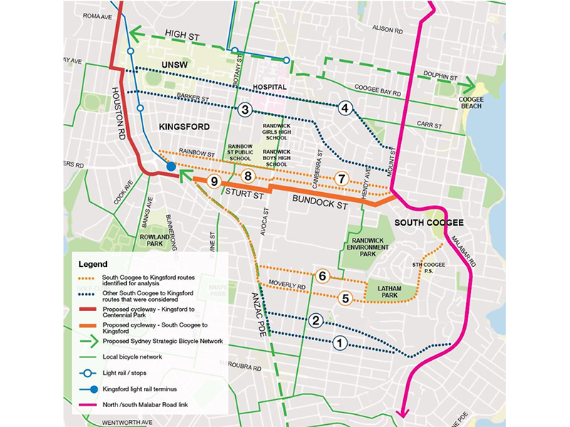
Map: Alternative east west bike routes
More information
- Council report 30 April 2019 – Route Options Analysis
- Cycleway project webpage
- Cycleway consultation website
Media Enquiries
Joshua Hay –0402 351 459 or joshua.hay@randwick.nsw.gov.au